
Natural Resources Canada
www.nrcan.gc.ca
Common menu bar links
Shaping the Harbour through Modern Geological Processes
Sediment bed forms in sand and gravel
- Sand Ribbons
- Megaripples
- Ripples in Gravel
- Gravel Circles
- Sedimentary Furrows
- Moats
- Georges Island Moat and Sediment Drift
- Bottle Collector Hole
Methane out gassing - pockmarks and subsidence areas
- Gas-Charged Sediments
- Pockmarks
Sediment bed forms in sand and gravel
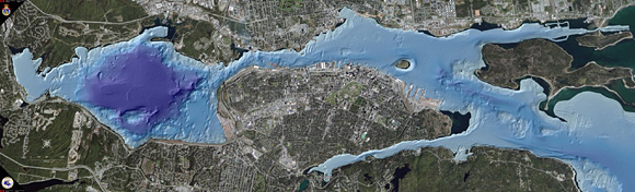
A map of the outer part of Halifax Harbour showing a variety of bedforms in sand and gravel at the seabed formed by strong currents and large waves.
A large variety of features called "bedforms" occur in the seabed sediments of the Halifax Harbour. They are formed in both coarse sand, gravel and fine-grained mud. Most bed forms in sand and gravel are modern features produced by strong currents and large waves. The bed forms help indicate how sediments move through the harbour and where contaminated sediments eventually are deposited. Features formed in muds can be both modern and old. The multibeam bathymetry from the outer harbour clearly shows a variety of sand waves, sand ribbons, as well as unusual features called "gravel circles".
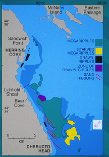
Bed forms in sand and gravel sediments largely occur in the outer harbour and include sand ribbons, megaripples, ripples formed in gravel, and gravel circles. They are rare in the inner harbour and Bedford Basin. Bed forms in muddy sediments include sedimentary furrows, sediment drifts, scoured depressions, moats, and obstacle-induced scours. The bed forms in the harbour indicate a general pattern of decreasing energy from south to north with occasional high-energy events related to storms. The following is a more detailed discussion of the various bed forms.
Sand ribbons
Sand ribbons, as the name implies, are thin ribbon-like rows of sand formed by strong currents. They occur only in the outer harbour and are confined to the western side near the steep granite bedrock cliffs. The presence of sand ribbons indicate where water flows the fastest in the harbour. These currents can flow up to 300 cm/s.
Megaripples
Megaripples are sand bed forms with a large ripple-like profile and are sometimes called sand waves. They are formed by currents that flow with a speed of 40–60 cm/s. The most northerly occurrence of megaripples occur adjacent to Sandwich Point. Their shape indicates transport and deposition of material up the harbour, from south to north.
The major zone of megaripples is confined to an area south of Lichfield Shoal. This area continues out of the harbour to Chebucto Head, mainly on the eastern side of the deep western outer harbour channel. North of Lichfield Shoal, there is an absence of large bed forms and the silty-sandy seabed has small ripples. This suggests that Lichfield Shoal acts as a barrier to strong inflowing bottom currents, protecting sediments directly off Herring Cove from strong fast currents.
Ripples in gravel
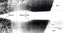
A sidescan sonar image of the outer part of Halifax Harbour showing how the seabed ranges from bedrock in the shallow costal zone through an area of ripples in gravel to sand in deeper water.
In many areas of the outer harbour in water depths between 10-20 m, large areas of ripples in gravel are present. They are more common along the Herring Cove shoreline, off Portuguese Cove, and in a few areas near southwest McNabs Island. They occur near bedrock shoals. They are straight, crested bed forms formed in moderately sorted mixtures of coarse-grained sand and fine-grained gravel (granules, pebbles, and cobbles) with shells. They are 1-2 m long and less than 0.3 m high. They are formed by large waves and are not a result of transported sediment. Samples collected in the gravel waves in the outer harbour contained over 70% broken shell debris and sea urchin spines.
Gravel circles
The most unusual bedforms found in the harbour are called "gravel circles". A field of approximately 90 gravel circles, each up to 25 m in diameter occurs in the outer harbour adjacent to Bear Cove Shoal on the eastern side of the deep outer harbour channel. The circles are slight depressions 20–40 cm lower than the surrounding sandy seabed and occur in 30 m of water. Sidescan sonar records show that in some groups, individual circles are connected by narrow, linear gravel deposits giving the circles a beaded appearance. They also occur as single, isolated circular features. Small patches of sand occur in the centre of many of the circles.
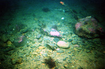
A bottom photograph inside a gravel circle showing that it is composed of gravel including small boulders.
Remotely operated vehicle video, submersible observations, and seabed samples confirmed that the circles are slight depressions of well rounded gravel rocks, in the cobble to boulder range, with shells.
The gravel circles form under storm conditions in the outer harbour. This part of the outer harbour lies in an area where the harbour narrows and shallows. Large vortices that represent an underwater equivalent of a tornado may develop in this area because of the narrowing, shallowing, and steep bedrock cliffs of the adjacent Bear Cove Shoal. These vortices scour the thin, overlying sand in a circular pattern and expose the underlying gravel sediment.
Sedimentary furrows
A multibeam bathymetric image of seabed features called sedimentary furrows in the western part of the outer Harbour. They occur as linear depressions in mud formed by strong currents they move from south to north.
A series of linear erosional scours in mud (LaHave Clay) occur in two areas in Halifax Harbour: at the boundary between the inner and outer harbour between Sandwich Point and Fergusons Cove, and in the Northwest Arm. The sidescan sonar records show that the furrow troughs consist of coarse sand and shells. They range up to 2 m deep and are almost 2 km long.
In the area off Sandwich Point the furrows fork, opening to the south, or seaward. They gradually shallow, narrow, and merge with the flat, muddy seabed in the north. The sedimentary furrows that occur in Northwest Arm are adjacent to Sir Sandford Fleming Park midway up the arm, and at the entrance to the arm. In this area the seaward starting point for the sedimentary furrows appears to coincide with shallow pockmarks (gas-escape craters). The roughness of the pockmarks may have started the development of the furrows.
The distribution and geometry of the sedimentary furrows adjacent to Sandwich Point show that the currents that formed them moved from the south to north towards the inner harbour. Furrows tend to form in areas where more sediment is deposited than eroded. In addition, coarse sediment plays an important role as it is transported and erodes the seafloor. The course grain that created these furrows comes directly from the seaward side of the furrows in Halifax Harbour. The sediment consists largely of sand, a ready source of coarse-sediment supply. Researchers think that unique circular flow within the bottom water is responsible for formation of sedimentary furrows. The sedimentary furrows are likely pernmantent features since they were always present during the 15-year survey. The presence of these furrows indicate that this area of the harbour, although a general area for mud to be deposited, is likely subjected to periodic and strong currents that erode the seabed.
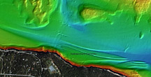
Moats
A multibeam bathymetric image of an area of Halifax Harbour to the south of Pleasant Shoal showing a large moat or depression. It occurs at the junction between mud and gravel where the seabed shallows. It is the result of non deposition of sediment by currents.
Sediment moats are a common characteristic of how mud (LaHave Clay) is deposited in the inner harbour. They occur in a variety of sizes and shapes, both associated with mud near bedrock and glacial features such as drumlins and moraines. The most common type of moat occurs at the base of steep slopes (toe-of-slope moat) where the mud (LaHave Clay) comes in contact with bedrock shoals and gravel-covered shallow areas. These moats are up to 3 m deep and can continue for distances up to 2 km following the mud-bedrock contact. The linear moats are confined to the area of the harbour between Pleasant Shoal and Sandwich Point, and in the nearshore areas of the Northwest Arm.
In other areas where bedrock protrude above the surrounding muddy seabed, moats can take the form of circular, isolated depressions. Geological information on internal layering in the mud indicates that most of the moats are not really erosional features, but result from a lack of deposition. This is due to the presence of increased currents or local turbulence that develops adjacent to topographic highs. With the exception of a large moat around Georges Island, moats are generally absent north of McNabs Island, likely as a result of decreased water current strength.
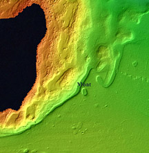
Georges Island moat and sediment drift
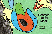
An interpretation of the multibeam bathymetry from around Georges Island that shows the location of the moat (5) and a sediment drift (3) to the north of the island. Area 9 represents the flank of Georges Island.
The Georges Island moat is a large horseshoe-shaped depression around the west, south, and east flanks of Georges Island. The maximum depths, 31 m occurs in the moat on the east side. The seabed at the base consists of glacial till (rock and other sediments left by ancient glaciers) and exposed lake sediments. Seismic-reflection profiles show that internal sediment beds within the LaHave Clay indicate that the moat is a not a result of deposition or erosion (other larger rocks scraping the sea bottom). It has persisted since the early deposition of LaHave Clay over 5000 years ago. Its formation resulted from the currents that flowed around Georges Island. As the water moves up the harbour, its speed increases around the island and this prevents sediment from settling. In the lee of the island there is (shallow of prevailing current-nothside in this case) an isolated mounded deposit (sediment drift) of LaHave Clay.
Sediment drifts are the opposite of moats and are localized deposits of fine-grained material, usually associated with a drop in current velocity and in the lee of topographic elevations, like snow drifts behind an obstacle. The sediment mound to the north of Georges Island is a sediment drift, that is, an accumulation of material on the current-sheltered lee side of the island. The sediment is more than 7 m thick. Its location to the north of Georges Island is evidence that this area has been an accumulation zone in the inner harbour since the first deposition of LaHave Clay.
Bottle collector hole
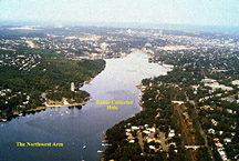
An aerial photograph of the inner part of the Northwest Arm. The bottle collector hole occurs in the narrowest area opposite Sir Sandford Fleming Park (Dingle).
Mud is deposited in two major areas of the Northwest Arm, and it is separated by an area of gravel and bedrock seabed adjacent to The Dingle (Sir Sandford Fleming Park). Here the arm narrows and the currents increase in velocity, forming a large sedimentary furrow. This linear depression is not the result of previous deposition followed by erosion, but merely a continued lack of deposition resulting from stronger currents that have persisted in this area of the arm.
The depression also acts as a trap for bottles thrown into Northwest Arm, hence the "bottle collector hole". Bottles thrown into the arm sink to the seabed in a neutral to slightly negative inverted position and move up and down the arm in response to currents and tides. Once in the depression off The Dingle, they become trapped. It is a popular dive location to retrieve old bottles.
Methane outgassing – pockmarks and subsidence areas
Gas-charged sediments
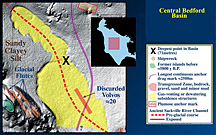
An interpretation of multibeam bathymetry from the central deep part of Bedford Basin. The regions in yellow are large depressions that were formed by the release of methane gas.
Both the LaHave Clay (mud) and the older buried lake sediments of the Halifax Harbour display large areas of gas charging. This is clearly seen on the seismic reflection profiles where the sound energy does not penetrate areas of gas. The upper reflector which represents the gas on the profiles occurs at a variety of depths ranging from the seabed in areas of Bedford Basin and the inner harbour to 15 m below the seabed. This effect is referred to as "acoustic masking" or "acoustic blanking" and is attributed to the presence of gas within the sediments. The gas most frequently associated with this characteristic is biogenic methane, which is formed when dead plant and animals decompose at shallow depths within the sediment.
It appears that the area of gas within the sediments has decreased since the first studies in 1974. One possible explanation for a decrease is from increased ship-related activities that impact the seabed, such as propeller-generated turbulence and widespread anchoring with larger anchors. Another possible explanation is that changes in bottom-water temperature and/or geochemistry within the sediments could cause increased gas venting.(releasing gas)
Associated with the shallow gas at the seabed of Bedford Basin are large deep areas of seabed outlined by linear scarps, seen as large horseshoe-shaped depressions. The northernmost depressed area merges with the southern, large, depressed area at their junction is the deepest depth of 71 m in the basin. These areas are interpreted to have formed by the release of methane-gas. Many of the large anchors from ships in the harbour penetrate the seabed to depths of between 1-3 m which suggests that the gas-charged layer is broken through in many areas possibly releasing some of the gas.
Pockmarks
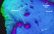
A large number of circular depressions occur in the LaHave Clay at the entrance to Northwest Arm. These are features termed pockmarks (gas-escape craters) similar to those first found in dense distributions in the basins of the adjacent Scotian Shelf. They display a variety of shapes from circular to ellipsoidal and range up to 3 m in depth and 45 m in diameter. They also have flat bottoms in contrast to the more typical cone shape of pockmarks in the basins of the Scotian Shelf.
The majority of the pockmarks are slightly elongated parallel to the orientation of the Northwest Arm. This suggests that currents may play a role in elongating them.
In the fall of 2003, Hurricane Juan made a direct pass over Halifax Harbour as it crossed Nova Scotia, resulting in a large amount of damage to homes, power lines, and in particular many trees in Halifax and Dartmouth. Winds were reported to reach a maximum of 198 km at Chebucto Head and waves reached 19 m high in the outer harbour. Many boats moored at the various yacht clubs throughout the harbour dragged and parted from their moorings and were pushed north up the harbour. Many eventually sank or were deposited above the present shoreline from tidal surges.
Questions arose as to what changes may have occurred on the bottom of Halifax Harbour from such a violent storm and would these changes affect the proposed new sewage treatment plants. The simple way to assess the effects of the hurricane was to resurvey the harbour with multibeam bathymetry and undertake a comparison with the earlier imagery. In the summer of 2004 the C.C.G.S. Frederick G. Creed conducted a series of small surveys of critical areas of the harbour where change, would have been expected to occur.
Four areas were surveyed: between ‘York Redoubt’ and McNabs Island, the entrance to Northwest Arm, an area south of Georges Island, and an area north of Georges Island where the outfall from the first sewage-treatment plant in Halifax was planned to be placed. A comparison of the multibeam bathymetry indicates that changes did occur in the outer harbour off ‘York Redoubt’, the entrance to Northwest Arm, and south of Georges Island. The area to the north of Georges Island does not appear to have been altered by sediment deposition or erosion.
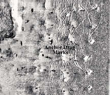
A sidescan sonar record of the seabed of the Northwest Arm at the Royal Nova Scotia Yacht Squadron anchorage area showing anchor drag marks form Hurricane Juan in 2003.
For the area south of Georges Island, new marks from anchor dragging and jack-up oil-rig circular depressions can be identified. Sediment erosion occurs around the shipwreck Havana. At the entrance to Northwest Arm, a sedimentary furrow now displays five large objects (possibly shipwrecks or buried features) that were not on the data collected in 2002. Sidescan-sonar data collected in October 2004 at the location of the moorings of the Royal Nova Scotia Yacht Squadron in Northwest Arm clearly show an extensive pattern of anchor-drag marks from the effects of Hurricane Juan.
Many of the erosional and depositional features on the bottom of the harbour have been formed or modified by large storms (strong currents and large waves); therefore, the fact that Hurricane Juan modified only a few small areas, suggests that larger and more energetic storms likely have affected the seabed of Halifax Harbour over the past several thousand years.